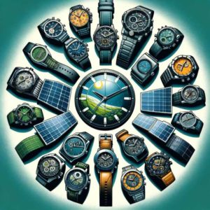
Earth in Focus

Wk 133 bio

Mr. Sudheer Kumar Shukla is senior research scholar of Department of Paper Technology, of India’s premier technological institution; Indian Institute of Technology (IIT) in Roorkee. He holds two master degrees in Environment; M. Sc. in Environmental Biology and M. Tech. (Hon.) in Energy and Environment Management.


eif week 133

Thank you to JM Suarez for providing the above image

Introduction

The Indian River Systems can be divided into four categories – the Himalayan, the rivers traversing the Deccan Plateau, the Coastal and those in the inland drainage basin (Figure 1). The Himalayan rivers are perennial as they are fed by melting glaciers every summer. During the monsoon, these rivers assume alarming proportions. Swollen with rainwater, they often inundate villages and towns in their path. The Gangetic basin is the largest river system in India, draining almost a quarter of the country.

The rivers of the Indian peninsular plateau are mainly fed by rain. During summer, their flow is greatly reduced, and some of the tributaries even dry up, only to be revived in the monsoon. The Godavari basin in the peninsula is the largest in the country, spanning an area of almost one-tenth of the country. The rivers Narmada (India’s holiest river) and Tapti flow almost parallel to each other but empty themselves in opposite directions. The two rivers make the valley rich in alluvial soil and teak forests cover much of the land. While coastal rivers gush down the peaks of the Western Ghats into the Arabian Sea in torrents during the rains, their flow slow down after the monsoon. Streams like the Sambhar in western Rajasthan are mainly seasonal in character, draining into the inland basins and salt lakes. In the Rann of Kutch, the only river that flows through the salt desert is the Luni. The major river system of India are discussed below.

Indus River System

The Indus originates in the northern slopes of the Kailash range in Tibet near Lake Manasarovar. It follows a north-westerly course through Tibet. It enters Indian territory in Jammu and Kashmir. It forms a picturesque gorge in this part. Several tributaries - the Zaskar, the Shyok, the Nubra and the Hunza join it in the Kashmir region. It flows through the regions of Ladakh, Baltistan and Gilgit and runs between the Ladakh Range and the Zaskar Range. It crosses the Himalayas through a 5181 m deep gorge near Attock, lying north of the Nanga Parbat and later takes a bend to the south west direction before entering Pakistan. It has a large number of tributaries in both India and Pakistan and has a total length of about 2897 km from the source to the point near Karachi where it falls into the Arabian Sea. The main tributaries of the Indus in India are Jhelum, Chenab, Ravi, Beas and Sutlej.

Brahmaputra River System

The Brahmaputra originates in the Mansarovar lake, also the source of the Indus and the Satluj. It is slightly longer than the Indus, but most of its course lies outside India. It flows eastward, parallel to the Himalayas. Reaching Namcha Barwa (7757 m), it takes a U-turn around it and enters India in Arunachal Pradesh and known as dihang. The undercutting done by this river is of the order of 5500 metres. In India, it flows through Arunachal Pradesh and Assam, and is joined by several tributaries.

Ganga River System

The Ganga (Ganges) rises from the Gangotri Glacier in the Garhwal Himalayas at an elevation of some 4100 metres above the sea level under the name of Bhagirathi. This main stream of the river flows through the Himalayas till another two streams – the Mandakini and the Alaknanda – join it at Dev Prayag, the point of confluence. The combined stream is then known as the Ganga. The main tributaries of the Ganga are Yamuna, Ram Ganga, Gomati, Ghaghara, Son, Damodar and Sapt Kosi. The river after traversing a distance of 2525 kms from its source meets the Bay of Bengal at Ganga Sagar in West Bengal.

Read more >>